
THE HEBRIDES
The completion of the historical and archaeological survey of those places in the Hebrides named after the papar1 follows on from the previous sections on Orkney, Shetland and Caithness (completed in 2005). It has been compiled by Dr. Janet Hooper, based on a preliminary survey by Lorna Johnston. The Evaluations at the end of each entry are by Barbara E. Crawford (BEC). The Inventory of place-names collected in the vicinity of sites H1-H8 was compiled by Dr.Anke-Beate Stahl and Dr.Kristjan Ahronson, and is inserted as a Downloadable Appendix. This toponymic material "Indicators of Ecclesiastical and Norse Settlement and History" is analysed by Richard A.V.Cox.
INTRODUCTION The papar names in the Western Isles are restricted to the north Hebrides.2 The reasons for this distinction between north and south Hebrides have already been speculated on above (3.2. Situation in the Hebrides; also in Crawford, 2005, 94). Is it a reflection of the different toponymic (place-name) pattern in the two areas? Or has it something to do with the pre-Norse political /ecclesiastical situation? Maybe the absence of papar places in the south Hebrides is a reflection of the nature of Scandinavian presence there which was different from Viking activity in the north Hebrides. It certainly does not reflect an absence of Christian monastic communities! The reasons are not obvious and the following discussion is a preliminary exploration of different aspects associated with the location of the papar places.
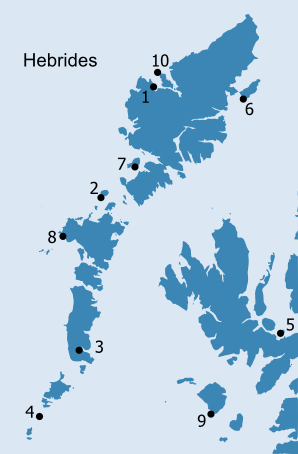
Starting with the all-important matter of geography, we can note that there are somewhat fewer papar places overall in the Hebrides (10) than have survived in the Northern Isles (7 in Orkney, 9 in Shetland plus 2 uncertain examples in Caithness). The majority are in the Outer Hebrides, with only two in the Inner Hebrides: Pabay near Skye (H5) and Papadil on Rum (H9). Those in the Outer Hebrides are primarily located on the Atlantic west side: Pabay on the west coast of Lewis (H1), with the nearby Pabanish on Little Bernera (H10), Paible on Taransay (H7), Pabbay in the Sound of Harris (H2), Paible in North Uist (H8) and Pabbay in the Barra Isles (H4). On the eastern side Bayble on the Eye peninsula (H6) faces on to the Minch, and Pabbay in South Uist (H3) lies in the inner part of Loch Boisdale, which opens out into the Minch.3 They are thus distributed fairly evenly throughout the Outer Hebrides, and altogether there are 5 island names (Pabbay and Pabay; papa-ey =’island of priests’), (H1-H5), 3 habitative Paible/Bayble names (papa-býli = ‘settlement/abode of priests’)(H6-H8), and 2 topographical names, Papadil (papa-dalr =’valley of priests’) and Pabanish (papa-nes = ‘headland of priests’)(H9-H10). These terms all correspond to the papar names in the Northern Isles, except for Pabanish, for which there is no Orkney or Shetland ‘Papness’ counterpart. The name Paible on Taransay is anomalous, in that this is an island which could have been called Pabbay, although as is noted below, the preference for a papa-býli name might have been to avoid confusion with the nearby Pabbay in the Sound of Harris. The consideration of ‘remoteness’ is frequently linked to the papar locations (see quotation from MacKenzie, 1903 (H1), that Pabbay islands were ‘chosen by Christian anchorites as fit places for meditation and prayer’). However, as is noted in the editorial comments at the end of some of the entries below, this consideration may be somewhat misplaced. Most of these islands, and the Paible places, were actually very accessible from the seaways, a consideration mentioned briefly in a discussion of the residences of the MacLeods of Harris and Lewis on Pabbay, Harris and Pabbay, Uig (H1 and H2) by R.W. Monro who noted that these islands are ‘to modern eyes and maps on the extreme outer limits of their territories’ (Monro, 1981, 18). Were they ‘second homes’ for these chiefs, places to ‘get away from it all’; or were they suitable centres ‘for ruling or administering a scattered domain’ when ‘the sea was man’s highway’ (ibid.19)? Similarly we should ask if these places were chosen by communities of priests because of their ‘remoteness’? They may have been chosen for other reasons, and accessibility from the seaways is one, while the quality of the land is probably another factor.
|
||||||
| Class | Class Description | Division description | ||||
| 4 | Land capable of producing a narrow range of crops. | 1) Land is suited to rotations which, although primarily based on ley grassland, include forage crops and cereal for stock feed. | ||||
| 2) The land is primarily grassland with some limited potential for other crops. | ||||||
| 5 | Land capable of use as improved grassland. | 1) Establishment of a grass sward and its maintenance present few problems and potential yields are high with ample growth throughout the season. | ||||
| 2) Sward establishment presents no difficulties, but maintenance may be restricted. | ||||||
| 3) Although sward establishment may be easy, deterioration in quality is often rapid. | ||||||
| 6 | Land capable of use only as rough grazing. | 1) Land has high proportions of palatable herbage. | ||||
| 2) Moderate quality herbage with mosaics of high and low grazing value. | ||||||
| 3) Dominated by plant communities with low grazing value. | ||||||
| 7 | Land of very limited grazing value. | This land has extremely severe limitations that cannot be rectified. Agriculture use is restricted to very poor rough grazing. | ||||
Table 1: Land capability for agriculture classes. (Soil Survey of Scotland, 1982) |
||||||
The last two – topographical - papar names may indicate rather different circumstances relating to the papar. Papadil in Rum (H9) is in a secluded situation and the name might not suggest that there was a papar settlement there of any permanence or significance (only indicating that the valley was associated with them in some way).4 It is classed as 6/1, although, along with a few other locations on Rum, was clearly capable of being farmed, while most of the island is rated 6/2, 6/3 and 7. Pabanish on Little Bernera (H10) is also classed as 6/1, but again the name may not indicate a definite papar settlement of the size or significance of the Paible and Pabbay places. The quality of the land in most of the papar locations in the Hebrides certainly points to the choice of these islands and Paible places for purposes other than eremitical retreat and reflection. However, some of the sites do have adjoining islands or islets which could have served as hermitages for a resident community on the larger island – such as Pabay Beag close to Pabay Mòr (H1) for instance. Paible on Taransay (H7) has a western headland, Aird Mhanais, with plenty of exposed coastline for the contemplative. The Monach islands lying opposite Paible in North Uist (H8) would have been a most suitable off-shore refuge for members of a monastic community in that location. The community founded by Becan of Rum would certainly have had a hermitage somewhere on Rum, but there were plenty of options, and whether it could have been at Papadil or not is only a guess.
A study of the map of early Christian sculptured stones (Fig.Intro.2 from Fisher, 2002) shows very clearly there is a total absence of early carved stones from almost all the papar sites.5 The notable exception is Pabbay in the Barra Isles (H4), where, however, the remarkable carved stone of early date is a Pictish symbol stone which suggests a secular rather than an ecclesiastical context. Of course the chance survival of such stones means that hard and fast conclusions cannot be drawn from absence of such evidence. But it is worth noting that in the local context of Pabay off south Skye (H5) early carvings have turned up on Raasay, Scalpay, and at Cill Ashaig, but none on Pabay, despite it being a fertile island with a chapel site. Even more striking is the presence of notable sculpture in the Small Isles on Canna, Eigg and Muck, and at two places on Rum, but none from Papadil. However, as already noted, this topographical name is no sure indicator of a permanent residential papar community, suggesting perhaps a connection at one remove with such a community, of which there were certainly some in the Small Isles (none of which have, however, given the papar name to their particular island or settlement). This absence of early sculpture from the majority of papar places in the Hebrides, has to be looked at in the context of many places where sculpture has been found but where the papar name was not given (or if it was, it did not stick). There is in fact something of a mis-match of evidence which is also warning us that the papar names may have been given originally for reasons other than purely the ecclesiastical connection with priests or monks. That connection may still have been a valid one, but other factors have to be brought into the equation.
It has been postulated for some time that the Scandinavian raiders gave these names because they left the papar alone on these islands and at the Papil/Paible locations, and it has also been suggested that they may therefore be evidence of an ‘unexpected tolerance’ for the priests of the Christian religion (Crawford, 1987, 166). More recently, a strong argument has been voiced by a linguist and place-name specialist that these names tell us that the Vikings lived alongside the priests ‘long enough for the papa place-names to be formed’, and that there is no reason to assume that they are not of Viking-Age coinage, but that they probably date back to the early period of colonisation and settlement (Gammeltoft, 2004, 44,46). This is a response and corrective to the ideas previously aired that there is a possible element of ‘retrospective naming’ involved, and that the names may actually date from a period subsequent to the early phase of raiding and settlement (MacDonald, 2002, 21-2; Lowe, 2002,94-5 and see my summary of these arguments in Crawford, 2005, 92-3). The implanting of the papar names must surely mean that the priests remained alive and in situ long enough to draw the close attention of the incoming Scandinavian settlers to them and their practices ‘whether religious, cultural or agrarian’(Waugh, 2007, 551-2). These papar names may thus have some significance for Viking priorities, although it is doubtful whether religious practices were of such significance in the early period of raiding and looting, when monastic communities were often on the receiving end of the Vikings’ violent treatment. Gammeltoft does suggest that the continued presence of the papar might signify ‘early attempts at converting the heathen Scandinavians’ (2004, 45), although expressing some reservations about this attractive (if unlikely) scenario.6 More to the point he goes on to surmise that the papar could not have been regarded as a threat, and perhaps ‘were seen as useful partners in one way or another’. Here is a line of enquiry which may help to explain the evidence of the names, and the question will be asked: how on earth could the papar be ‘useful partners’ to the pagan marauders, who were the antithesis of their own creed and way of life?
This cannot be denied. Therefore the question of supply of produce by the farmers of these fertile soils, and of the cows, sheep, pigs and goats reared on these lands, raises the hypothesis that they may have been sources of food for the Vikings in an era before they settled on the islands themselves and took over the farming of the land. There does not appear to have been any full consideration of the issue of the Vikings’ food supplies, although the practice of strandhögg is known (see entry in Vigfusson and Cleasby, Icelandic-English Dictionary) when the Vikings are supposed to have landed on beaches and rounded up the cattle for provisioning their boat crews. In Ireland it appears that monasteries were used as sources of food. Already in 798 the church on St. Patrick’s Island was burned, followed by ‘cattle tribute’ being taken from nearby territories, although this is apparently a ‘unique record’ (Etchingham, 1996, 38). It has been suggested that another method was practised in Ireland, when raiding bands plundered monasteries for supplies of food and slaves on Christian feast days, but left the community to build up resources again for the next time supplies were required (Crawford, 1987,45-6 citing Smyth, 1977, 167; Etchingham, 1996,44; Woolf, 2007, 56). The few sources which refer to the Hebrides in the early Viking period do not mention such methods, although we know about the raids on Iona, from the Irish Annals; and the recurrence of such raids (in 795, 802, 806, and 825) suggests strongly that the community survived them. It certainly must have done, for Columba’s relics were still there in 825, before being removed a few years later (Crawford, 1987, 46). The monasteries were productive power-houses and therefore unlikely to be entirely destroyed, for this would deprive the Vikings of vital sources of supply. There is no evidence that such exploitative activities were also pursued in the north Hebrides, but it can be said that most monastic communities, including those we assume lived on the islands and other places named after the papar would have been valuable suppliers of agricultural products. Is it possible therefore that the papar name was given to the Pabbays and Paibles because of their known value as places with surplus products, with an organised community which farmed the land and which could be prevailed upon to provide the raiders with necessities of food and other commodities?
It does appear likely that raids on Ireland in the early 9th century may have been conducted from bases in the Hebrides (Woolf, 2007, 58-9). We do not know where these bases were: for practical purposes it may however be fruitful to look at the papar places in relation to movements through the seaways. Approaching the Outer Hebrides from the north it is possible to sail either down the west side, exposed to the Atlantic, or down the more sheltered east side, through the Minch. It seems very likely that both routes would have been used, depending on weather conditions,9 political conditions, and final destination.10 If the former route was used Pabay, Uig (H1), Paible on Taransay (H7) and Pabbay, Harris (H2) were all strategically located. The first is an ideal refuelling stop for mariners moving south along the inhospitable north-west coast of Lewis, at the access point to the sheltered waters of Loch Roag; Taransay dominates sailing access to Tarbert and the isthmus which is the narrowest crossing point to the eastern sea route along the Minch; Pabbay, Harris is exceedingly prominent and important in the historical record and situated at the centre of the Outer Hebridean chain of islands it controls access through the Sound of Harris to the eastern side. The next papar place on the route south is Paible, situated in the centre of the fertile machair of North Uist, although topographical change makes it difficult to know how accessible this site may have been from the sea in the Viking Age. On the eastern side of Lewis the fertile Eye peninsula juts out into the northern approaches to the Minch, and Bayble (H6) is situated on the coastal side of the peninsula and highly accessible from the sea. There are then no more papar places along the highly indented and rugged eastern coastline of Lewis, Harris and North Uist until the Papay islets in Loch Boisdale/Baghasdail, which as discussed below (H3) are not at all comparable with the other papar islands. Nonetheless this Papay situation had some useful strategic qualities, being in a very sheltered natural harbour and with easy access to fertile machair lands to the west. Finally there is Pabbay in the Barra Isles (H4), at the southernmost limit of the island chain and accessible from both western and eastern sailing routes-a strategic outpost for any seafarers, whether Christian priests or pagan raiders. The last Pabay (H5) to be drawn into this maritime geographical survey, is the only one in the Inner Hebrides, and closest to the Scottish mainland. What is so particularly significant about this small island located in the outer reaches of Broadford Bay and only a couple of miles off the coast of south-east Skye? Its position close to Kyle Akin makes it a highly strategic island, at the very northern access to the important sailing route through the narrows to Loch Alsh and the Sound of Sleat. Then there is the enigmatic Papadil on Rum, (H9) an outpost of all the papar places, and which also has something of a strategic position, facing south as it does towards the southern Hebrides. So what conclusions can be drawn from this geographical analysis of the position of the Pabays and Paibles and their fertility? Any conclusions must only be tentative, and suggestions as to their role are entirely hypothetical. First of all is the restriction of the nomenclature to the northern Hebrides, which may have some explanation in the circumstances of the early Viking period.11 The absence of papar names in the part of the Hebrides where the most renowned of the monastic communities were located-Iona, Tiree, Canna- may suggest that the Vikings had a different relationship with the Christian communities here. Perhaps this was a result of the political situation in the southern Hebrides, and the position of the kingdom of Dál Riata. Perhaps it was a result of the Vikings’ own needs and requirements regarding supply bases along the sea routes. Focussing on why the papar names are only in the north Hebrides, and bearing in mind the discussion above about the productivity of these places and their strategic importance along the sea routes, it may be suggested that these islands were significant in the early Viking control of the north Hebrides. Perhaps they played a role in the raiders’ establishment in the islands in the initial phase of impact and consolidation of authority? We assume that the Vikings must have established bases from which they raided the Irish monasteries, and these would be on the islands and headlands convenient to the sea routes. They would need supply bases also, which the papar establishments may perhaps have been which leads back to the idea that the papar were ‘useful partners’. By leaving the papar in place the Vikings could have benefited from the continuing supply of produce from these fertile establishments. This would not have necessitated any accommodation with the Christian religion, merely a working relationship that benefited the papar as much as the Vikings. If this was so, then the restriction of the papar names to the northern Hebrides may reflect a situation which stemmed from the earliest phase of raiding when the Viking ships’ crews had control of the north Hebrides, from where they launched their attacks on the Christian monasteries to the south, including of course Iona.
Where place-names are concerned the toponymic evidence needs further analysis. It was long ago postulated that the absence of early Norse names in Papa Westray in Orkney (see above O2) pointed to a situation in which that island was left alone in the early phase of settlement (Marwick, 1924-5, 36). by and bister names do appear to be absent from the Orkney Papa islands although the latter name probably once existed in Papa Stour, Shetland (see above S1). It also survives in the toponymic record for one of the Pabbay islands discussed below (H1). This does not however prove that Norse speakers settled in Pabbay, Uig, in the first phase of raiding. Bólsta∂r names have been put later in the chronology of settlement names than Marwick designated (Nicolaisen, 1969, 15; Gammeltoft, 2001, 162-3) and in general we are nowadays much less certain about what sort of habitative names can be treated as early or late. Understanding of geographical factors and the need to look at these places from the sea rather than from a territorial viewpoint is absolutely essential. The importance of the Lewis and Harris Pabbays (H1 and H2) as residences for the early Christian papar and the later MacLeod chiefs may relate in both cases to their accessibility to the seaways, rather than to their remote location ‘on the outermost fringe’. This aspect was also likely to make these places extremely important to the mobile Viking sea-farers, and as discussed above, may be the reason why they gave them names highlighting their occupation by groups of Christian clerics. What needs also to be explored further is whether these Christian groups might have also chosen these places for their strategic situation. If so, it may relate to their links with other papar communities across the sea in the Faeroes and in Iceland.12
The role of the Vikings was always known to be significant because they gave the papar place-names, but that role has come into sharper focus through the ideas about why they gave these names (which are explored above). The totality of the evidence relating to the papar places which is now gathered together enables us to view the whole maritime picture from north to south and to gain a more comprehensive understanding of why these papar names may have been given to the Pabbay islands and Paible places. It should be stressed that the suggestions made above about the significance of the Vikings’ role, and their collaborative relationship with the papar, are only preliminary suggestions. It is hoped that consolidatory work will follow on from the basis which this project has established and further our understanding of both the early Christian and Viking periods in the insular world, whether in support of these suggestions or contrary to them.
The Carnegie Trust for the Universities of Scotland is to be thanked by all participants in this project for two funding awards and also for additional financial help with the illustrations. Their support enabled this inter-disciplinary project to be pursued, and brought to completion. It now provides an easily-accessible source of reference for historians, archaeologists, place-name researchers and all those who wish to learn more about the enigmatic places in the ocean associated with the priests of the early Christian church in the insular Celtic world. The pictorial and cartographic evidence for these remote places is absolutely essential for our understanding of their geographical location. The aerial photographic collection of the RCAHMS has proved particularly valuable and several images enhance a number of the Hebridean sites discussed below. The collection of early maps in the Map Library of the NLS is also an extremely valuable resource as the earliest cartographic record of the places and their names, and we are grateful to the NLS for allowing these images to be used free of any reproduction fee; similarly also St. Andrews University Library. We are particularly indebted to Hamish Haswell-Smith, who generously gave us permission to use the exceptionally clear and useful maps from his wonderful book The Scottish Islands (2nd edition 2004). The Russell Trust have continued to be supportive, and are thanked once again for the ready response to requests for financial support in both phases of this project, particularly with regard to the funding of web-site preparation costs. The Hunter Trust and the Catherine Mackichan Trust provided additional financial help with research expenses. Acknowledgements for advice and information on the Hebridean sites are due to Mary Macleod, Carol Knott, Rachael Barrowman, Jill Harden, Pat Foster; for permission to use photos: John Raven, Pat Foster and Cathy Dagg; for assistance in making information available: Highland Libraries, Highland Archives, Highland Council Archaeology Unit, Seirbhis Arc-eolas nan Eilean Siar/Western Isles Archaeology Service and Leabharlainn nan Eilean Siar/Western Isles Libraries. Various colleagues have given help and of their time in the process of bringing this material to web publication. Alan Muirden, Education and Outreach Operational Manager, and Cole Henley and Philip Graham, RCAHMS, are to be thanked for their professional role in adding the Hebridean material to the web-site. Dr. Simon Taylor, Dr. Cathy Swift, Donald McWhannell, and the members of the papar research group, all provided useful suggestions and corrections. Bill Jamieson from the University of Stirling assisted with cartography. The papar group’s regular meetings at the Dept. of Biological and Environmental Sciences at the University of Stirling were always positive and constructive, and Beverley Ballin Smith (GUARD), Dr. Janet Hooper, Dr. Jo Thomas (McKenzie), Dr. Doreen Waugh, along with the two authors of this Introduction have worked amicably and effectively together in bringing to completion this inter-disciplinary project. We have successfully combined our expertise in widely-different fields and the results show how valuable and how necessary it is for practitioners of different disciplines to learn how to work in partnership when studying a topic of this diverse nature. The papar are an elusive concept, but we hope that they and their maritime world have become more accessible through the gathering of different sources of evidence and from being viewed through a wide geographical spectrum. March 2008 |
||||||
| 1For a discussion of this term and what it is understood to mean see above Section 2.3 ‘Linguistic Evidence’ |
||||||
2Kilphubile in Mull (Kilphobull in 1588, RMS, v, no.1491) is identified by Gammeltoft (2001, 301) as a possible papa-býli name but Maclean 1997, 29 derives the second element from Gaelic pùbull (m) ‘tent, booth’. There is also a Gaelic word pobull (m) ‘people, tribe, nation’ (information kindly provided by Simon Taylor) |
||||||
7See ‘Papar Place-Names in the Northern and Western Isles of Scotland: A preliminary assessment of their association with agricultural land potential’ by I. Simpson, B.E. Crawford and B. Ballin Smith’ above, where it is said that ‘it is clear that the majority of papar names in the N. and W. Isles are associated with areas of very good to medium quality agricultural land, which, with the agricultural land management of the period, would allow good yields’. |
||||||
9for instance the presence of coastal fog, which all navigators seek to avoid. The frequency of fog appears to be far greater in the southern Hebrides than in the north Hebrides (see map in Crawford, 1987, fig.15), although it is prevalent to some degree in the Minch (less than 100 hours per annum). However the west side of the Outer Hebrides is fog free, except for a patch (100-199 hours per annum) along the coast of the Uists. This may have meant that the western sailing route was sometimes the preferred sailing route. |
||||||
)
)