
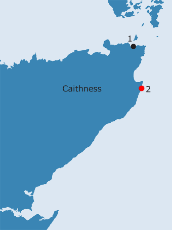
CAITHNESS: C2. Papigoe, Broadhaven, nr. Wick · Introduction Papi Geo is a long, narrow rocky inlet on the north side of Broad Haven, to the south of which is the North Head of Wick and the mouth of Wick Bay (NB, Caithness, Book 13, 180). Although the derivation of this name from ‘papar’ appears to be an attractive one, an alternative interpretation has been put forward by the author of the New Statistical Account: ‘A passage is said to lead a considerable way from the sea, to a small knoll called the Pap, whence the name of Papigoe’ (Thomson 1841, 118). If Papigoe is not restricted to the small inlet to which its name relates today, but applied to the broader area which the name Papigoe covers on the OS First edition map (1872), Thomson’s explanation becomes understandable. On this map, Papigoe, described as a small district with a number of dwellings (NB, Caithness, Book 13, 181), incorporates Broad Haven, at the head of which is the large broch still known as The Pap (RCAHMS 1911, 160-2, no. 520; Batey 1984, 76, WIC 161; NMRS/SMR no. ND35SE5, NGR ND 3762 5140). Its position ensured that this broch acted as a very visible fishing mark for those navigating in and around Broad Haven (George Watson, pers. comm.).33 Significantly, Broadhaven is called Papiego Haven on Arrowsmith’s map of 1807 and, although slightly less clearly defined, this also seems to be the case on Bryce’s map of 1744 and Dorret’s of 1750. Similarly, on Gordon’s map of 1642, Papingo applies to two separate settlements and to the headland between them, making it appear very similar to the OS First edition map of three centuries later. Another mound lying towards the north end of the village and therefore closer to Papi Goe may also be significant in this context (RCAHMS 1911, 190, no. 585; Batey 1984, 75, WIC 154; NMRS/SMR no. ND35SE7, NGR ND 3828 5176; the NGR given in the record does not match the position of the mound on the ground). Even though ploughing suggests that it is a natural mound (since little stone has been revealed), it may also have been utilised as a fishing mark. Elsay Geo, the next inlet to the north of Papi Goe, also has a large broch at its head (RCAHMS 1911, 162-3, no. 521; Batey 1984, 75, WIC 152; NMRS/SMR no. ND35SE6, NGR ND 3871 5198). The hint of an ecclesiastical connection for Papigoe is suggested in landholding records from the early modern period. Wick appears to have been one of the six parishes reserved to the bishop in a charter of 1223-45 (OPS, Vol. II.2, 771). In 1601, the 10 pennylands of Weik and Papigo with the crofts called the Bischopis Quoyis and Kenzeochis Quoyis….’ were annexed to the earldom of Sutherland and then granted anew to the earl (ibid., 776). Although Papigo is not mentioned specifically in earlier charters which include the same lands, it is interesting that there is a connection with the bishop and that the name is associated with a ten pennyland estate. Although Early Christian ecclesiastical sites can be found in close proximity to, or even on top of, sites of earlier secular significance such as brochs (e.g. Chapel Hill and Dunbeath broch at Ballachly in Dunbeath Strath), in the case of Papigoe it is certainly possible that the name derives from the prominence on the skyline of these particular features (whether natural or not).
A pre-Reformation chapel dedicated to St Ninian is thought to have been located on the North Head of Wick and therefore on the south side of Broad Haven. The six-figure grid reference given for the chapel in the NMRS/Highland SMR places it on the rocks of the foreshore (NMRS/SMR no. ND35SE8, NGR ND 383 508), although (if present at all) it clearly must have lain somewhere on the headland itself. Locating the chapel is complicated by the fact that there are no known upstanding remains (Myatt 1975, 81, 84; Batey 1984, 76, WIC 160; Watson 1991), while very little information concerning it is apparent in the documentary record. A position on the south side of the headland is still pointed out locally as the site of the chapel (Nan Bethune, pers. comm.).34 The earliest documentary reference to the chapel is in 1726, when it is mentioned in a ‘Geographical Description of the Parish of Week’, compiled by Mr. Oliphant, then minister (1726, 160). This mentions that ‘At the head of Wick is the Chappel of St. Ninian’. Succeeding references are few and equally imprecise, seeming merely to repeat this information (e.g. Thomson 1841, 160; OPS, Vol. II.2, 772; Auld 1858, 3; Horne 1895, 27; Mackay 1914, 31). Although the North Head of Wick is referred to more frequently in the sources, it appears merely as a topographical feature, a ‘dangerous promontory’, on the north side of Wick Bay (Thomson 1841, 160). The origin of the name Proudfoot, which is also applied to this area and, on the OS First Edition map (1872), appears to refer specifically to the rocks of the foreshore, was not discovered in the sources consulted in this study. On the earliest map of a scale to reveal any detail of the area, (Blaeu’s map published in 1654), nothing is shown at the North Head. Beaton, in his study of the parishes of Caithness at the end of the nineteenth century discusses St. Ninian’s chapel at some length. Although he does not cite his sources, Beaton uses the dedication of the chapel at the North Head to St. Ninian as confirmation of the importance and early date of the site (1909, 52-3). This perceived importance must have been well known in Caithness at this time as Horne, two years earlier, states that St. Ninian’s was the ‘repute earliest religious building in the county (1907, ?). Ninian dedications are few in the Highlands (Navidale, near Helmsdale, in Sutherland is the nearest, geographically, to Wick); all are historically obscure and provide no context for the possible association of Ninian with Wick and certainly no proof of the significance implied by Beaton. There is little, in archaeological terms, to corroborate the presence of Christianity in Caithness prior to the eighth century and, certainly none linked to a conversion of the far north by Ninian, who would have been active in the fifth century (although his cult did undergo a revival in the twelfth century). In light of the numerous Early Medieval chapels which dot the Caithness landscape, it is likely that St. Ninian’s was nothing more than a small local chapel of pre-Reformation date. It is possible that when the more formalised parish structure of the late twelfth century came into being, St Ninian’s lost out to its more favoured neighbour, St. Fergus in Wick, disappearing just as the historical record becomes more informative. Wick was almost certainly one of the six churches reserved for episcopal use by Gilbert in his constitution of the see in 1224 x 45, (OSR, no.9), although it does not appear in Bagimond’s Roll at the turn of the thirteenth century (ibid. no.16; Cowan 1967, 210). A vicarage had been established before the Reformation, but as the parsonage revenues remained with the bishop, it is likely that the episcopal drain on the resources of the parish affected parochial provision, resulting in its later obscurity. This leaves unanswered the question with which Beaton was more concerned, to resolve the ‘diversity of opinion as to the exact location of this Chapel’ (1909, 53). He states that the ‘general interpretation’ is that a chapel at the head of Wick [Bay] refers to one on the North Head. However, if Wick bay is viewed in a more restrictive sense, then the chapel could have been situated at a point close to where the Wick river opens out into the bay, on the east side of the present town centre and near to the present service bridge (ibid.). This area of Wick is still known as Mounthoolie (ND 3654 5106). The only indications that this name might preserve the location of St. Ninian’s chapel are contained in two seventeenth-century references in the Wick Burgh records, although in both cases it is a ‘St. Ninians Head’, rather than a ‘St. Ninians Chapel’, which is mentioned. In 1663, a fight took place between a merchant and a tailor ‘at St. Ninian’s Head, below the said burgh’ (Beaton 1909, 53). This would seem to support the suggestion of the Mounthoolie area, since the North Head could not be described as lying below the town. The only other reference to St. Ninian’s Head is less easy to locate precisely, since in 1665, the Earl of Caithness ordered a watch for Dutch shipping ‘within the town’, at St. Ninian’s Head. This could just as easily refer to a watch placed close to the Old Ship Pool, near the Service Bridge, as to one kept on the much more prominent, but more distant, North Head (ibid.). Beaton, following the author of the New Statistical Account, also suggested that the pre-Reformation parish church of St. Fergus was situated in this area, only shifting to its present site following the Reformation (Thomson 1841, 161; Beaton 1909, 54; Batey 1984, 77, WIC 169; NMRS/SMR no. ND35SE10, ND 365 510). In addition to the placename, Beaton’s evidence consists of the remains of a building, a possible font and a hoard of fifteenth century gold coins found opposite Mounthooley House in 1881 (Beaton 1909, 54; Batey 1984, 77, WIC 170; NMRS/SMR no. ND35SE9, ND 3645 5108); however, a font found in the farmyard of the UP manse, on the south side of the Wick river, in 1840 was also meant to have come from ‘the old chapel of St. Fergus’ (Beaton 1909, 54-5; RCAHMS 1911, 189-90, no. 582; Batey 1984, 78, WIC 175; NMRS no. ND35SE21, SMR no. ND35SE0257, ND 365 510). The present site of St. Fergus’s church, which contains a medieval effigy of a knight, traditionally believed to be St. Fergus himself, lies further to the east (Sutherland 1791, 33; Thomson 1841, 142; RCAHMS 1911, 135-6, no. 493; Batey 1984, 78, WIC 172; NMRS/SMR no. ND35SE1, ND 3619 5113). That there was early medieval religious activity in and around Wick is confirmed by a portable altar - a small, square slab, incised with a central cross and with four crosslets in each of the corners - which was dredged out of Wick Bay (Thomas 1971, 194-5; Batey 1984, 78, WIC 174; Blackie and Macaulay 1998, 20; Fisher 2002, 44). While neither reference to St. Ninian’s Head is particularly explicit, the fact that both refer to a named headland, suggest that confusion could have arisen between the North Head and one closer to the heart of the old burgh. This could be especially true if St. Ninian’s chapel had gone out of use at the Reformation and, with the rise to prominence of St. Fergus’s as the parish church, faded out of memory.
This Caithness equivalent of Papa Geo in Shetland (Site S4) is in a part of the Norse world where there are no reliable indicators of any nearby ‘papar’ establishment or early Christian presence. The ‘pobi’ names in Shetland appear to be some evidence for the association of the ‘papar’ with coastal features in later folklore, and it may be that this name should be classified the same. It is possible that the name has subsequently become understood to refer to the nearby mound or pap (W.P. Thomson, pers. comm.). This is given some weight by the association of a ‘papar’ name with a Ninian dedication, which in Orkney and Shetland, is a combination sometimes applied (by antiquarians) to sites perceived to be of ecclesiastical significance in the pre-Norse period.
OS maps:
| |||||||||||||||||||
33Doreen Waugh has added the following comments on the name Papigoe:
|
|||||||||||||||||||
34Robert Gunn and Iain Sutherland of the Wick Heritage Society believe that they have identified (by dowsing) a possible site for St. Ninian’s chapel on a narrow headland between Papigoe itself and the adjacent inlet to the east (Otter Geo). |
|||||||||||||||||||
)