ORKNEY: O4. Paplay, South Ronaldsay · Introduction South Ronaldsay is described as ‘fertile in Corns and abounding with People’ in the late seventeenth century (Wallace 1693, 7); Papley, itself, consists of lime rich farmland (Lamb 1995, 17), reflected in the name Lime Banks, shown on the First edition map for the area to the north of St. Peter’s Church and Manse Bay.
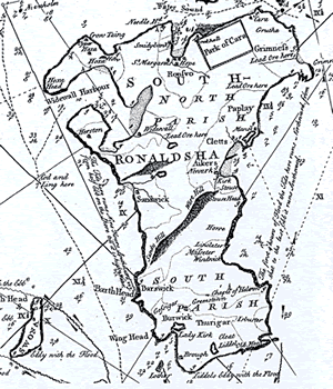
In addition, on his way south from Grimness towards the manse, Low ‘saw several deep holes which I was informed were sunk in search of Lead ore’, although only small quantities were revealed (1774, 23). ‘Lead Ore here’ is marked on Mackenzie’s map (Fig.04.1).
Although the name no longer appears on the modern editions of the OS map, in the late nineteenth century, Paplay, located on the north east coast of South Ronaldsay, was described as a small district comprising several small farms (NB, Orkney, Book 20, 177). In fact the district is about a mile in length. The lands of Paplay are mentioned as a ninepenny land in the earldom rental for the years 1492, 1497-1503 and 1595 (Peterkin, no. I, 21; no. II, 95; Thomson 1996, 36). A perambulation in 1677 of the bounds of the township, dealing with each of the nine pennylands in turn, contains a detailed description of the township divisions, in addition to throwing considerable light on contemporary agricultural practice (Clouston 1920, 19-20; the original document, unfortunately not discussed in full by Clouston, was contained in the Heddle of Cletts charters, which have subsequently been lost - William Thomson, pers. comm.). The name, Paplay, apparently lying within an enclosure, is shown on Aberdeen’s map of 1769, while on both Sawyer and Bennett’s map of 1781 and on that compiled by the Depot Generale de la Marine in 1803, the name, a church and a house are shown. The name also appears - as Paplay or Papley - on the maps of Mackenzie (1750), Arrowsmith (1807) and Thomson (1822). On the First OS edition map, the district of Paplay - running more or less parallel with the coast - covers the area lying to the north of the parish church of St. Peter, which is however central to the district. The church lies close to the shore, at the head of a small bay. Immediately to the west is the farm of Kirkhouse, while the manse lies slightly further away to the north; a number of names in the vicinity reflect the presence of the church, farm and manse (Kirkhouse Bay, Kirk Taing, Kirk Ness, Manse Bay and Manse Taing). To the east of the church are the remains of a fishing station, kelp kilns, and a windmill, while a large boat clearance extends out into the Pool of Cletts, at the head of Kirkhouse Bay. To the north, between the church and the manse, is a possibly prehistoric settlement mound, lying amidst what is now marshy ground, but which was once a loch (NB, Orkney, Book 20, 178; RCAHMS 1946, 289, no. 838; NMRS no. ND49SE7, ND 4728 9130). In local tradition, there are stories of a souterrain close to the manse, as well as cist burials at Kirkhouse (Willie Palmer, pers. comm.). A tall standing stone, although positioned at the bottom of a scarp slope, forms a very prominent feature overlooking the church; Low could discover no traditions regarding the stone, nor did he recover anything by digging around the stone itself (1774, 25; Gerard 1841, 193; RCAHMS 1946, 286, no. 821; NMRS no. ND49SE3, ND 4691 9140; see Barry’s description above). A second standing stone apparently stood closer to the shore, until made unstable by drainage operations carried out after WWII (Willie Palmer, pers. comm.).
South Ronaldsay was divided into two unequally sized parishes.24 St. Peter’s covered the northern two thirds of the island, including Paplay, while St. Mary’s formed the southern third (Watson 1793, 181; Gerard 1841, 191; FES, Vol. VII, 229). St. Peter’s church was united to the church of Our Lady and to the church of Burray (dedicated to St. Laurence) by 1440; the subsequent history of St. Peter’s and Our Lady appears to remain identical until they were disjoined at the end of the nineteenth century (FES, Vol. VII, 213, 229; Clouston 1918, 228; Cowan 1967, 186). The parson of the united cure of all three churches was named as a canon of the cathedral in 1488 and it is possible that the parsonage was one of the original prebends of the cathedral, although it is not referred to in Bishop Reid’s reconstitution of the bishopric in 1544 (Cowan 1967, 186). In this reconstitution, the vicarage of Ronaldsay was assigned to the provost of Orkney, along with the maintenance of the church of Barwick and the prebend of the Holy Trinity (ibid.; Cowan equates the church of Barwick with Burray, but it seems as likely to be the Lady Kirk at Burwick). Part of the corn teind appears to have pertained to the vicar and the cure itself was served by a vicar-pensioner (ibid.). In spite of the fact that the parishes had been conjoint since 1440, two parochial churches - St. Peter’s and St. Mary’s - are mentioned in the report on the teinds of the Orkney parishes of 1627 and by Monteith in 1633, while a church on Burray had, according to Brand in 1701, been annexed ‘tyme out of mynd’ (Peterkin, no. III, 84-5; Brand 1701, 54; Monteith 1845, 4; Tudor 1883, 337).
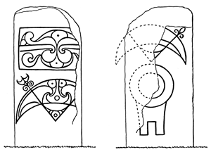
Chapel Dedications and Locations Uniquely in the case of South Ronaldsay, the report of 1627 also names the chapels - nine in total - which were dependant on the parish churches: Sant Androis at Woundwick, Our Ladie at Halcro, Sant Colmis at Loch of Burwick, Ruid chappell in Sandwick, Sant Tola [Olaf] in Wydwall, Sant Colme in Hoxay, Sant Margrat in the Howp, Sant Colmeis in Grymnes and Sant Ninian in Stow (Peterkin, no. III, 86-7). The dedications of these chapels are suggestive of pre-Norse Christianity but can they be relied on as evidence of continuity through the period of Norse settlement and establishing of a medieval church? Alongside the parish churches, their locations imply a network of small chapels extending around the coasts of the island. In 1627, all the chapels had associated lands. In the majority of instances, this was clearly privately owned (Clouston 1918, 91-2); only in the case of those linked to St. Andrew’s was the individual landowner unknown (Peterkin, no. III, 86-7). The author of the first Statistical Account noted that the ruins of seven old chapels were to be seen in his day and that it was believed ‘some of them were erected by mariners, who, despairing of life in tempests at sea, vowed to build a church on their arrival at the first harbour’ (Watson 1793, 305). Half a century later, Gerard believed that there were indeed nine chapels, eight of which had associated burial grounds (1841, 193). Remarkably, the locations of all nine chapels are still known, even if few physical traces can now be seen in many cases; this seems to imply that all may have survived the Reformation, but - as Gerard’s description hints - perhaps only as places of burial. Clouston notes two ‘kirkgeo’ placenames (in the south parish), which seem to imply the presence of chapels already forgotten by 1627 (1918, 97) and there is also the 3d land of Kirk on the east side of the island which, in spite of its name, does not appear to be associated with a church or chapel (Marwick 1952, 172). Scott lists five chapels - Halcro, St. Margaret’s Hope, Stow, Burwick and Windwick - which were dependent on St. Peter’s church (FES, Vol. VII, 229, 233). If the north-south division between the two parishes is preserved, then St. Colm’s at Hoxa and St. Olaf’s at Widewall would complete the pattern around the west coast of the island; certainly both Wydwall and Hoxay were listed as part of St. Peter’s parish in the rental of 1595 (Peterkin, no. I, 19-23). Clouston has equated the five chapels listed by Scott with the burial districts, which themselves appear to relate to other landholding divisions, such as urislands (1918, 93-5). Families were bound to bury their dead within the burial district in which they lived and also to attend every funeral within that district. At the time that Clouston was writing, this custom still pertained in parts of Orkney and, even where this was not the case, the bounds of the district were often well-known (ibid., 93-4). Each burial district might contain at least one chapel and, although no tradition surrounding the burial districts of South Ronaldsay was known to Clouston, he set the 1627 chapels within those divisions associated with the lawrikmen (ibid.; the background to this is discussed in more detail in Clouston 1917, 58 and passim). In the first district was the chapel and burial ground of St. Olaf in Widewall and, in the second, the chapels of St. Colm at Hoxa and St. Margaret in the Hope (Clouston 1918, 96, 233). In the third district, that immediately to the north of Paplay, was the chapel of St. Colm at Kirk Geo, lying on the north side of Grymnes, now Grim Ness (ibid.; NMRS no. ND49SE24). The fourth district contained the parish church and St. Ninian’s chapel and burial ground at Stows. Stowshead towers over the area of Paplay to the north (NB, Orkney, Book 20, 243-44; Craven 1891, 6; Clouston 1918, 96, 233; NMRS no. ND48NE3), while the lands of Stowis (now Stews) are listed in the earldom rental of 1497-1503 (Peterkin, no. I, 22; no. II, 96); there were also kirklands attached to the chapel (ibid., no. III, 87; Clouston 1918, 96, 233). If Scott is correct in assigning the other chapels on the east coast to the north parish, then a fifth district comprising the chapel and burial ground of St. Andrew’s at Windwick, with Our Lady at Halcro, needs to be attached to the north parish (1918, 97, 233). However, St. Colm’s at Burwick must surely stay with the south parish. St. Peter’s Kirk (SMR no.1816) The discovery of a Pictish symbol stone, slightly trimmed and re-used in a window, suggests that this church site has a long history (Stuart 1856, 30, Plate XCVI; Allen and Anderson 1903, 20-1; RCAHMS 1946, 290, no. 842; Fisher 2002, 45, n.3; NMRS no. ND49SE1). On one face of the slab is a crescent and V-rod, ornamented with scrollwork, below a similarly decorated panel, while on the other face is a mirror-case underlying part of an undecorated crescent and V-rod (see Fig.04.2)(Stuart 1856, 30, Plate XCVI; Radford 1962, 173; Fisher 2002, 45; the stone is now in NMS, Edinburgh). Much of the surface of the face displaying the crescent and mirror case has flaked off, but it is possible that this side of the slab was never finished, as the remaining parts of the symbols seem to have been intentionally deleted by pecking (Close-Brooks and Stevenson 1982, 23; quoted in Fisher 2002, 45). St. Peter’s at Paplay does not have an association with a broch, nor does it lie outside the later parochial system, the two most important factors which Lamb utilises to characterise the Orkney ‘Peterkirks’ (Lamb 1995, 19); nonetheless, it is the only St. Peter dedication to be associated with a papar name, while the symbol stone appears to confirm that this is an early site.
· Soil Survey of Scotland Class 52 (area round the manse and St. Peter’s church) 42 (north of the manse)
OS maps:
|
||||||||||||||||||||


